Mapping Africa Transformations

Security
Instability is on the rise in the Sahel and West Africa. Violent events and civilian casualties are increasing. Our tools help policy makers to better understand the geography of violence which leads to better designed, place-based and contextualised policies. Security is analysed under four dimensions: i) the Spatial Conflict Dynamics indicator; ii) conflict networks; iii) borders and iv) urban/rural.
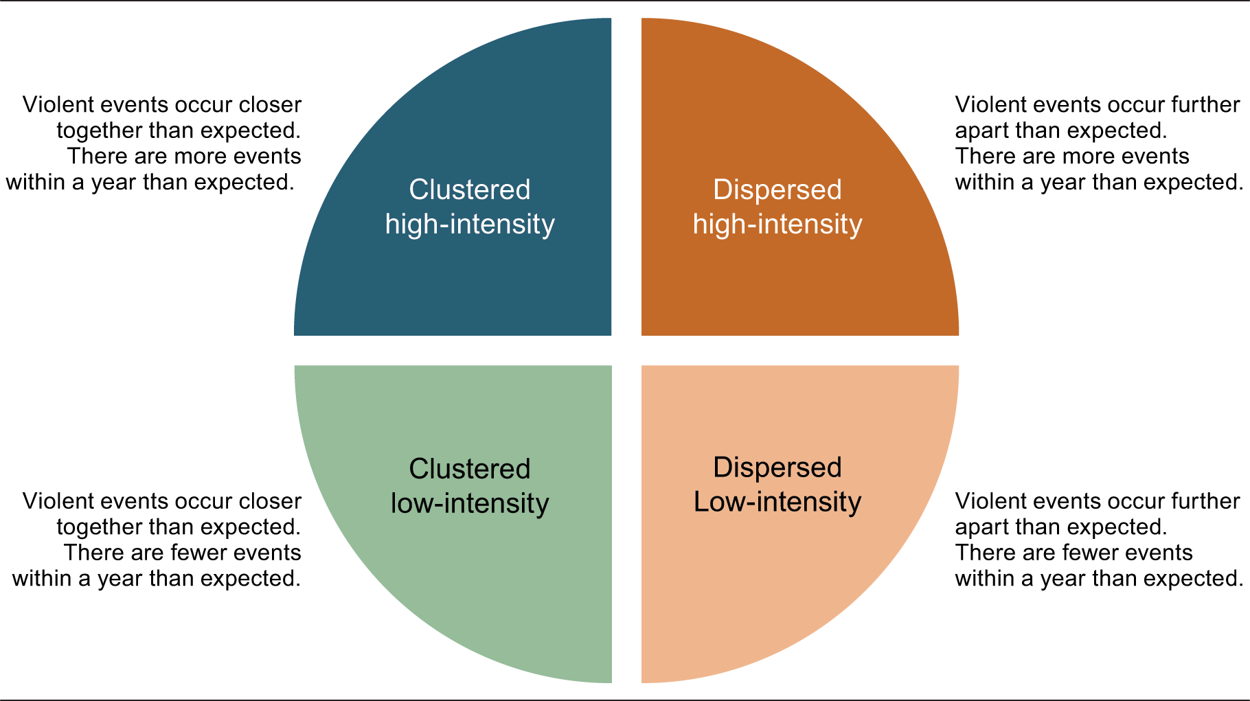
The Spatial Conflict Dynamics indicator (SCDi) maps the temporal and spatial evolution of political violence in North and West Africa since 1997. It divides the region into 6 540 cells of 50 by 50 km and analyses over 60 000 violent events from the Armed Conflict Location & Event Data Project (ACLED) across 21 countries. Four conflict types are classified by i) their intensity and ii) their concentration. The SCDi was developed by the Sahel and West Africa Club (SWAC/OECD) in co-operation with the University of Florida’s Sahel Research Group . See the code for the SCDi here.
Types of conflict
Overview
Since 2011, the region has been engulfed in a wave of political violence, eclipsing that of the late 1990s and early 2000s, when several conflicts took place in the Gulf of Guinea, Côte d’Ivoire, Sierra Leone, Liberia and Guinea. The last five years were amongst the most violent ever recorded due to the sharp rise in political violence targeting civilians and border regions. Between 1997-2023, 64827 violent events and 229795 fatalities have taken place in North and West Africa. West Africa accounts for 70% of all violent events and 74% of fatalities. The situation is particularly worrying in the Sahel with an increase in the number of organisations involved in violence.
Find out more:
- Identifying local conflict trends in North and West Africa
- The fragmentation of conflict networks in North and West Africa
- The Geography of Conflict in North and West Africa (including three case studies on Mali and Central Sahel, Lake Chad and Libya).
Major hotspots of violence
Between 2021-23, over 90% of violent events and fatalities were concentrated in only five countries: Nigeria, Burkina Faso, Mali, Cameroon, and Niger. Nigeria is the main epicentre of violence, accounting for 45% of all North and West African fatalities between 2021-23. Nigeria is home to three major conflicts: i) the Boko Haram insurgency in the Northeast, ii) communal conflict between pastoral herders and farmers in the Middle Belt and iii) the Niger Delta insurgency in the south. Borno state, in northwestern Nigeria, is a major cluster of intense violence which has expanded to neighbouring countries.
In central Sahel, community conflicts, coup d’état and terrorist violence are all overlapping. Tensions in Mali are spreading southwards. Burkina Faso is the second-most affected country after Nigeria, with 4663 violent events and 15058 fatalities recorded in 2021-23. In Niger, violent events and fatalities are concentrated in the Tillabéri region, bordering Burkina Faso and Mali.
Violence subsumes nearly all the borderlands along the Mali-Burkina Faso-Niger border, from Sikasso in the west to the W National Park in the east, forming a 1200 km by 200 km band of conflict. The dark blue cells indicate where violence is concentrated and of high intensity.
In the Lake Chad region, there is a long line of high intensity violence from N’Guigmi (Niger) to Mubi (Nigeria) and Maroua (Cameroon). Rural zones remain highly insecure and the impact of the insurgency on agriculture production, pastoralism and the civilian population is overwhelming.
Violence is spreading to previously unaffected areas
Four countries – Burkina Faso, Mali, Niger, and Nigeria – account for 68% of areas newly experiencing conflict in 2022 and 2023. However, 11% of those areas were in Benin, Côte d’Ivoire, Ghana, Guinea, and Togo, highlighting the diffusion of violence from the Sahel to the coastal countries. Most violent events in these states in 2022-23 were attacks against civilians (67%) followed by battles between armed groups (29%) and explosions or other forms of remote violence (4%).